A damaged 'too difficult to read' sketch made by Turner in 1802 is revealed in this 2025 research paper to be a detailed and accurate drawing of this view - except that today the glaciers are much receded- image © John Lumby 2024
A damaged 'too difficult to read' sketch made by Turner in 1802 is revealed in this 2025 research paper to be a detailed and accurate drawing of this view - except that today the glaciers are much receded- image © John Lumby 2024
by John & Prue Bishop
It has long been thought that JM Willian Turner made no sketches as he and Newby Lowson trekked around the western side of Mont Blanc from Chamonix to Courmayeur, but our research reveals a series of detailed, large and accurate studies.
Our research paper was published in the newly launched British Art Journal in 2025, so please support this new art history research venture :
In this on-line version here of our research paper, we will update our findings from time to time
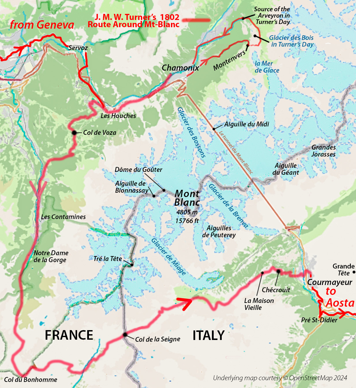
Plate 1: Turner’s 1802 Treck Around Mont Blanc from Chamonix to Courmayeur is marked in red on a current map © OpenStreetMap 2024 that includes the location of today’s Mont Blanc Tunnel and the greatly-reduced extent of today’s glaciers. Today, this is part of the recommended Tour of Mont Blanc trek known by its abbreviation as “The TMB”. Turner’s group came from Geneva on a mule track passing through Servoz. The map also includes their excursion crossing the Mer de Glace that in their day extended into the long-gone Glacier des Bois to the point marked Source of the Arveyron. Locations mentioned in the text are included.
In 1802, the ratification of the Treaty of Amiens allowed artists an all-too-brief chance to travel freely across Continental Europe, and as has been documented by many scholars, the 27-year-old J M William Turner and a colleague Newby Lowson successfully completed an outstandingly ambitious tour that included part of the Alps. In this research paper, we present new findings about his route, the weather and gain an insight of views that must have impressed him greatly.
It has long been thought that Turner made no sketches as he and Lowson trekked around the western side of Mont Blanc from Chamonix to Courmayeur, but our research reveals a series of detailed, large and accurate studies.
The reference works are all from the Turner Bequest that is available for public viewing on request at London’s Tate Britain. We provide both the traditional ‘TB’ and the current ‘D’ references, our own comparative images and revised or entirely new titles as appropriate.
During August 1802, Turner, Lowson and almost certainly their Swiss guide and a local guide completed an arduous hike around the Western side of Mont Blanc from Chamonix to Courmayeur. Today, this route forms half of the challenging Tour du
Mont Blanc (TMB) trekking route that circles the mountain as described in detail in guide books and on the Web. Every year there is even an international race: the Ultra-TMB that is limited to 3000 athletes of whom about a third never make it to the finish. Plate 1
The 1802 Continental tour was central to Turner’s development as an artist, marking the beginning of his many visits abroad that eventually established him as one of Europe’s leading artists; greatly influencing many that followed.
The entire tour was adventurous for the time and must have resulted from a very careful consideration of the limited publications available, in order to arrive at a viable route. A few rather generalised maps had been published in England, but almost everything else was in the French language. It therefore seems likely that Turner acquired sufficient French to understand these publications. Indeed, he eventually titled every drawing in his Grenoble sketchbook from this tour in his rather phonetic version of French. French was well-established as the language of diplomacy, and Napoleon had already effectively extended France into Switzerland, Savoy and Piedmont.
The late 1700s saw the emergence of a factual and scientific interest in the Alps and especially the Mont Blanc Massif. In England, two subjects were gaining special attention: science and climbing.
The detailed scientific publications in French by Geneva’s Professor H-B Saussure from 1779 onwards would have been read with great interest in London. His unique observational skills extended into what today we would call geology, minerology, physics, meteorology, hydrology and nature. He included descriptions of the mountains and details of routes as far away as Sicily, later writing about his Alpine studies as follows:
During this time I crossed the main chain of the Alps fourteen times by eight different routes, besides making sixteen excursions into the centre of the chain.
He attempted to climb Mont Blanc and offered a prize to incentivise the discovery of a successful route - achieved by Paccard and Balmat in August 1787. An Englishman was not far behind: Colonel Mark Beaufoy organised a team that was the fourth to stand on the peak that same summer.
We may be sure that this veritable barrage of exciting achievements and scientific investigations was being strongly picked up by those known to Turner, thereby motivating him to wish to view the related and extraordinary topography for himself.
The trek from Chamonix to Courmayeur Fig 1 would have taken four days, sleeping rough or in very basic accommodation. For this part of the journey, here crossing and later re-crossing the Alps largely on foot, he carried three sketchbooks: a small and a medium-sized one purchased in Paris: the France, Savoy Piedmont Sketchbook (TB LXXIII about 14 x 22 cm) and the Grenoble Sketchbook (TB LXXIV about 21 x 28 cm), together with a much larger one of grey-washed paper brought from England: the Gothard and Mont Blanc Sketchbook (TB LXXV 48 x 32cm) Plate 2 that is central to this research paper.
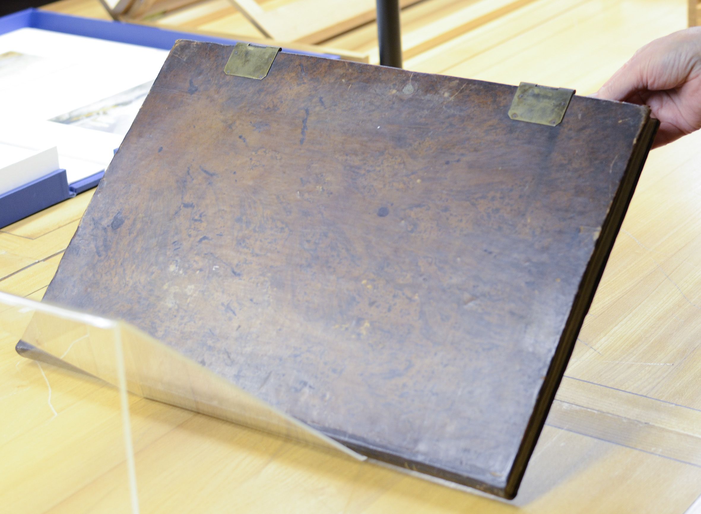
Plate 2. TB LXXV The Saint Gothard and Mont Blanc Sketchbook. Calfbound with two brass clips. 325 x 584 x 25 mm Image © John Lumby at Tate Britain ref: 20111116-8712
The physically-demanding nature of the journey would have discouraged carrying bulky items, so he must have considered it essential to bring along such a large sketchbook, in addition to the smaller ones . Its dimensions are 325 x 584 x 25 mm or about 13 x 19 x 1 inches. At the start of the trek, it already contained 21 sketches, all relating to Mont Blanc; six completed with watercolour. It is therefore no surprise that important sketches are in fact in this sketchbook, although remaining either partially or completely unrecognised until now.
We often suggest to those wishing to understand Turner that they themselves should hike this same route, as its fatiguing nature, for those of us that are not athletes, provides an insight into the character of the man, especially as he did it again in his sixties !
As Turner left no written accounts of his journeys, we rely on recognising his sketches to determine where he went. The problem with this is that most of his sketches were made with only sufficient detail to assist his amazing visual memory. So for us, they are often a puzzle, and we have to try to work out the scene. When one finds a match, Turner’s lines suddenly make complete sense, above all when compared with a photograph from the same viewpoint, as we shall see here. For him, the match with his memory would of course have been instant.
In opening a study of this particular sketchbook, these words by A J Finberg in the 1909 Complete Inventory of the Drawings of The Turner Bequest set the scene for the difficulties with interpreting the most damaged drawings:
This book has been almost entirely disintegrated, only six leaves remaining in the covers. No record has been kept of the sequence of the pages. Mr Ruskin appears to have numbered some of those he had laid down on cartridge, but the numbers evidently refer to some scheme of arrangement of his own, and not to the original order of the pages. The order in which the pages are now placed is largely fortuitous.
A note inside the sketchbook reads:
Replaced in old binding 1935. Blank leaves added where drawings have been taken out & mounted.
Unfortunately, some pages of this sketchbook were probably already badly damaged and even lost by the time Turner arrived home, as they are water-damaged and scuffed. These include the ones recording the trek around Mont Blanc that remain in the sketchbook, presumably as they were thought to be of no particular importance. The pencil lines were anyway applied lightly to the grey paper, and over time they have lost graphite, making them exceptionally difficult to comprehend.
Other pages from deeper in the sketchbook remain readily recognisable, with 18 of them having been individually mounted for exhibition.
It is reasonable to consider Turner and Lowson as among the very first tourists. The first comprehensive European guide Guide des Voyageur en Europe was published in Weimar in French by Reichard in January 1802, and in Volume 2 of the 1805 edition pages 560 to 578 there are detailed recommendations as to how to get to Chamonix and full descriptions of what one might wish to see once there, and it even provides the names of 25 guides. All this information would have been available locally in Chamonix in 1802 and collected around that time to update and extend Reichard’s comprehensive publication.
We therefore consider Turner and Lowson not as explorers, but rather as among the very first tourists, coming mainly at that time from England and Germany that had the considerable means needed to fund expensive travel that was completely out of reach for the ordinary citizen.
They would have certainly engaged one of those guides to see them safely round this little-used Mont Blanc route on which some had already perished. They would also have retained their own probably armed Swiss guide to see them back over the Alps via the Grand Saint-Bernard Pass to Martigny: into an increasingly politically and militarily-disturbed Switzerland where they had arranged for their cabriolet to be parked ready for a much easier onward adventure.

Plate 3 JMW Turner, Official Title: ‘’The River Arve with Distant Aiguilles’. TB-LXXV-3, D04593. Suggested title: ‘The Chamonix Valley and Chamonix from the Col de Voza Pass, with part of the Mont Blanc Massif with the Aiguille Vert in the distance. In the centre, the peak of Le Brevant mountain is just visible behind a nearby mountain. Pencil on paper 315 x 473 mm with Turner’s lines over-drawn. Image Lumby 20111116-8717a with insert of rhe peak of the Brevent, Image Lumby 20220818-38271.
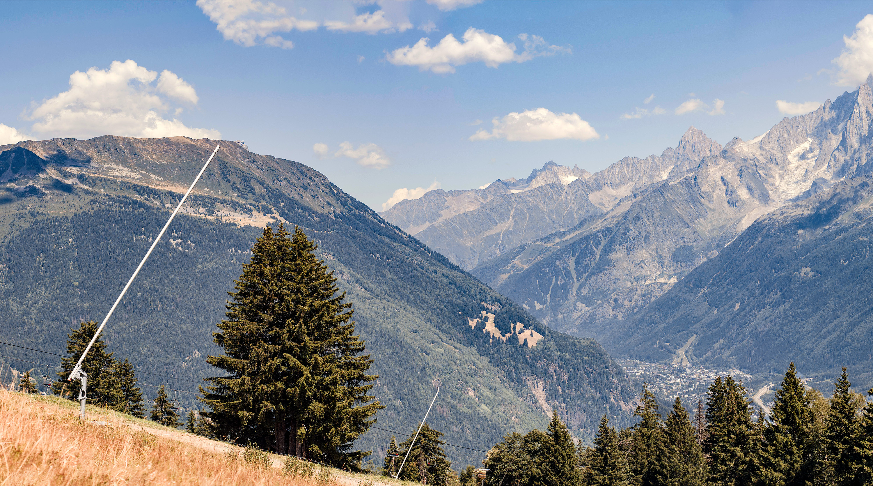
Plate 4 Compare with Plate 3., Vew from the TMB at the Col de Voza looking along the Chamonix Valley to the Aiguille Vert, Image © Lumby-20220810
Having completed their comprehensive tour of the main Chamonix sights, notably in viewing and crossing the already famous Mer de Glace glacier that terminated in the ‘must see’ Source of the Arveyron Ice Cave, they would have set out on foot on their 80 km or 50 mile trek very early, quickly completing the first 8km or 5 miles to Les Houches, followed by climbing steadily 8km / 5 miles through woods to the Col de Voza Pass where Turner immediately recorded two magnificent views in his Gothard and Mont Blanc Sketchbook: Plates 3 and 5.
This pass, the highest of this first day, may today be reached by cable-car from Les Houches, or by the little one-metre gauge mountain railway from St-Gervais-les-Bains opened in 1901. Turner’s drawing Plate 3 is accurate given it would have been done quickly. We may be sure that we are precisely on the Col de Voza because only at this point does the tip of the Brévent peak just becomes visible behind the nearer part of the mountains on the opposite side of the Arve Valley, as we see in the circular insert. Although difficult to decipher, Turner has also added the word ‘Arve’ by the river. This highest part of the Arve Valley is usually called the Chamonix Valley, and the town in the valley is Chamonix itself.
As stated in the official title, most of the peaks in this view are called aiguilles or needles, the most prominent, over on the right under a small cloud, being the Grand Dru 3654m 12316ft, first climbed in 1878, that borders the far side of the already-visited Mer de Glace. Below this peak and a little to the right, Turner has the slope entirely covered by glacial ice, whereas in our photo most of this slope is now covered in green vegetation. This ice used to feed into the Bossons Glacier.
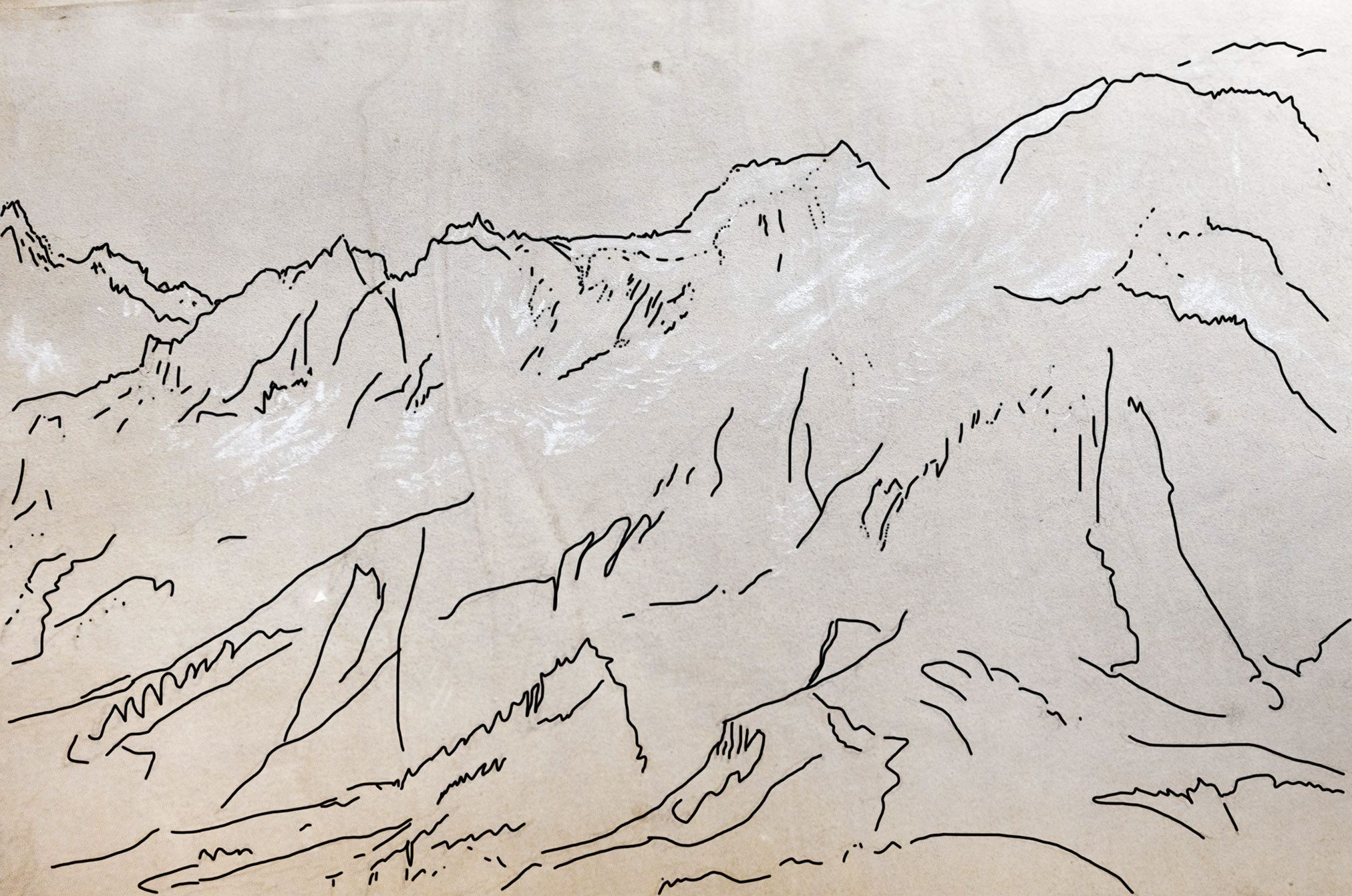
Plate 5 JMW Turner, Official Title ‘Mont Blanc and Slopes of the of the Aiguille de Bionnassay’, Our title ‘The view from the Col de Voza Pass above Les Houches of the Alps South of the Chamonix Valley from a distant Aiguille Verte to the nearby Dôme du Goûter 4304m, TB-LXXV-3a D04594 pencil on paper 473 x 315 mm Image Lumby 20111116-8718 with over-drawn lines for clarity.
The extreme top right of Turner’s sketch Plate 5 is the rounded shape of the Dôme du Goûter, 4304 metres or 14,120 feet; the third-highest summit of the Massif: a view slightly to the right of the previous one and well to the left of The Aiguille de Bionnassay mentioned in the official title. His white chalk shows us how extensive the glaciers once were; indeed, the Dôme had glaciers on all sides
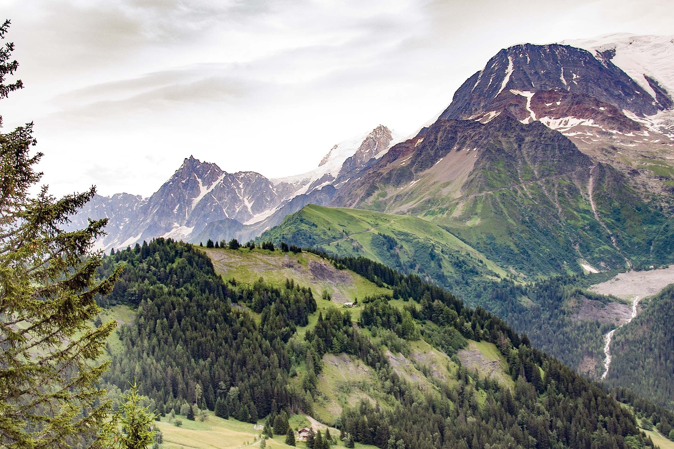
Plate 6 Compare with Plate 5. View from the TMB at the Col de Voza Pass of the North Side of the Mont Blanc Massif from a distant Aiguille Verte 4122m to the flat-topped Dôme du Goûter 4304m that lies next to the paek of Mont Blanc that is not visible from this viewpoint. Image © John Lumby
Today, the comparative photograph (taken from the train well before the Col de Voza stop), shows almost no glaciers, and we are informed that those that remain are likely to all be gone by the end of the present century. Today’s TMB makes a dramatic descent, crossing the meltwater stream seen in the photograph by a suspension bridge that in Turner’s day would have been well inside the glacial ice Our travellers would therefore have descended through the woods to the road that still leads to Les Contamines where he made two sketches: folio 24 that is mounted for display and not included here, and a very damaged folio 25 - Plate 7 - placed here to demonstrate the difficulty of interpreting the sketchbook’s remaining sketches
 D04617 Lumby20111116-A8750-to-54crop.jpg)
Plate 7 JMW Turner 1802, Les Contamines Church and Mountains Looking South TB-LXXV-Folio 25 still in the sketchbook) D04617 Lumby 20111116-A8750
In this case, the church was readily recognised many years ago. Whilst the pencil lines of the mountains are largely lost, the chalk of the glaciers, top left, remains clear. We have cropped away the right-hand and lower parts of the image as the original lines are no-longer visible due to scuffing and water-damage.
What then follows is an unlikely gap in the sketches, as Turner would have observed some amazing views and surely recorded them. These may still lie hidden somewhere in the vast Turner Bequest holdings, although the most likely situation is that they no-longer exist. For instance, Turner would surely have sketched in detail the absolutely captivating view from the Col de Seigne Pass 2516m as they crossed today’s Franco-Italian border, as this includes the peak of Mont Blanc, the unusual shapes of ‘the pyramids’ and the view down the length of the Val Veney with, in his day, magnificent glaciers tumbling into this valley from the left. Be assured that we have searched diligently for his sketch of this missing view: Plate 8 :
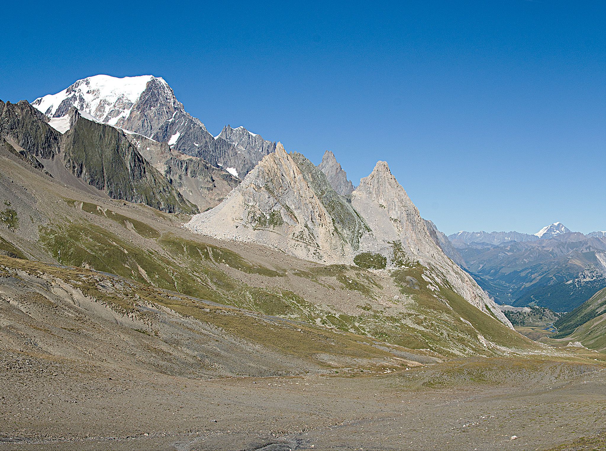
Plate-8 View from the Col de la Seigne Pass down the Val Veny: Mont Blanc 4808m, The Pyramids, Between the Pyramids is the Aiguille Noire de Peuterey, and in the far distance Le Grand Combin 4314m Image ©Lumby 20110828
The descent down the Val Veny is today hindered and in Turner’s day effectively blocked by the Glacier de Miage (see Plate-1) forcing a climb out of the floor of the valley, but leading to splendid views of the Mont Blanc Massif from the top of the climb and the subsequent direct trail towards Cormayeur.
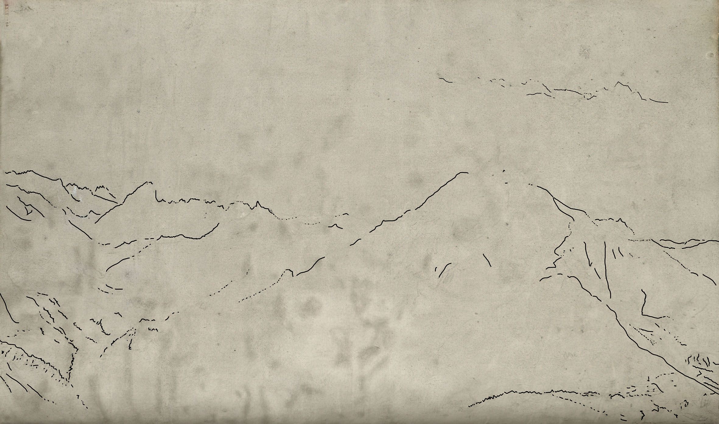
Plate-9 Official Title ‘Mountain Crests’ TB-LXXV-4a D04596, pencil on paper 315 x 473 mm, with Turner’s lines over-drawn for clarity, Image Lumby 20111116-9719
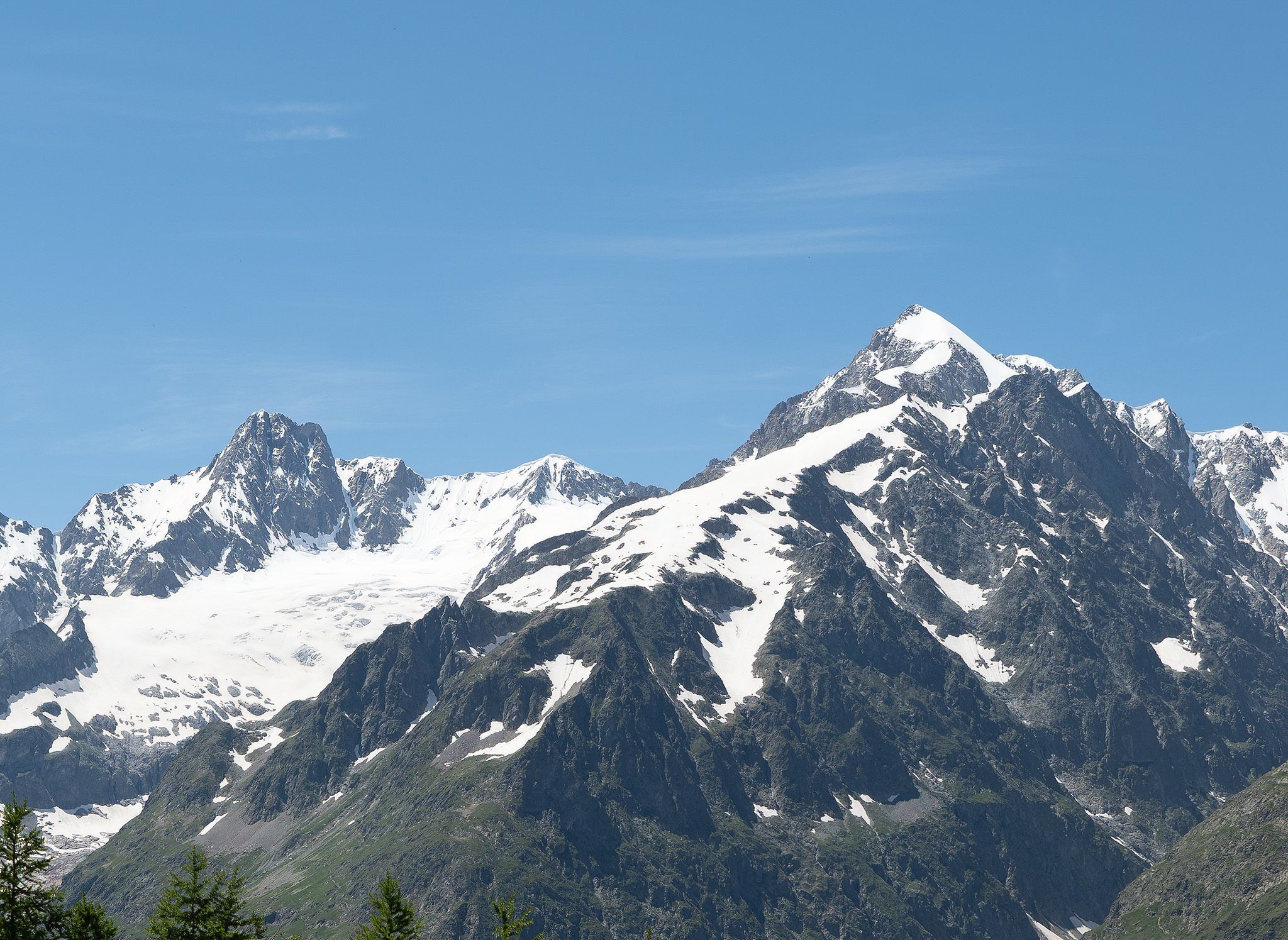
Plate-10 Compare with Plate 8, Left to Right: The Aiguille des Glaciers 3185m, the Aiguille de la Lex Blanche 3684m with below these first two peaks the Glacier de la Lex Blanche, and on the right the Aiguille de Tré-La-Tete 3930m, Image ©Lumby20240708_a_P4JB2105
Plate 9 may be the view in Plate 10 with presumably the peak of the Tré-La-Tete in cloud. If our comparative image is correct, the viewpoint is not far from that for Plates 11 and 12
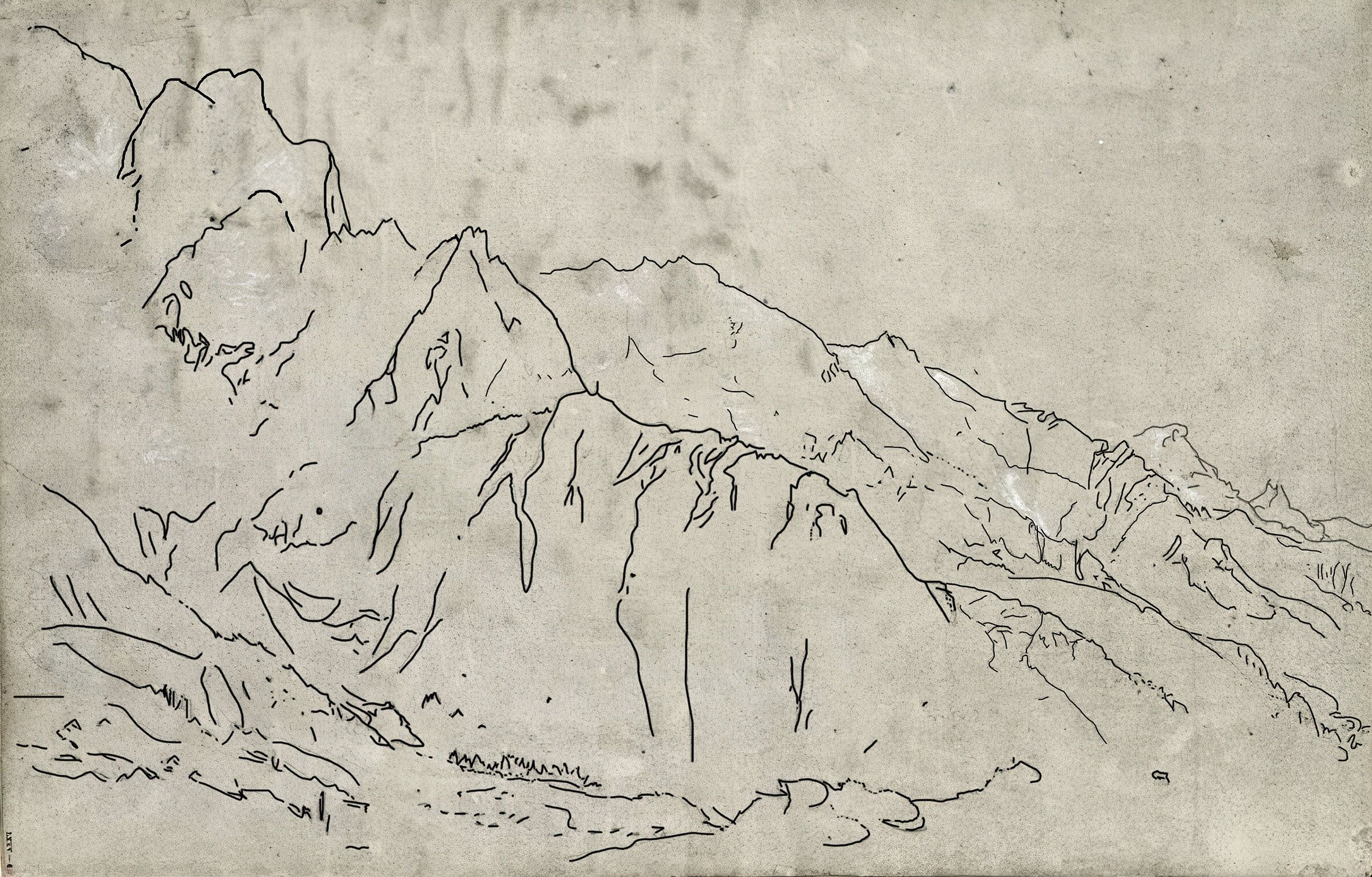
Plate-11 Official Title ‘Range of Mountains’ TB-LXXV-4 D04595 pencil on paper 315 x 473 mm, with Turner’s lines over-drawn for clarity, Image Lumby 20111116- Turner’s viewpoint location is 45.77847°N, 6.90669°E
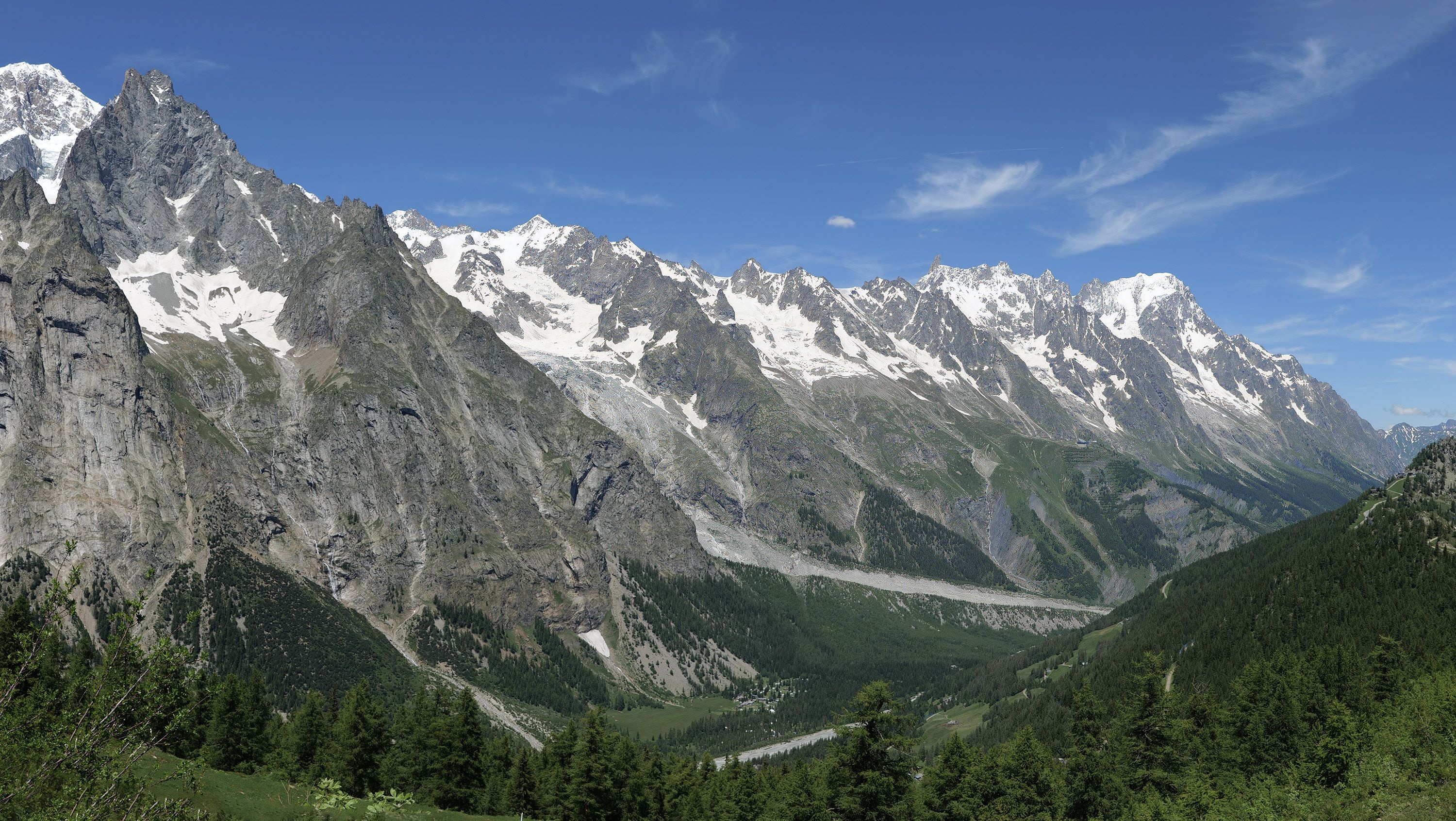
Plate-12 Compare with Plate 11, Mont Blanc extreme left, with the Massif on the North side of the Val Vany viewed from the TMB near Lac Checrouit looking NNW. Image © Lumby 20240708_a_P4JB2031+2+3
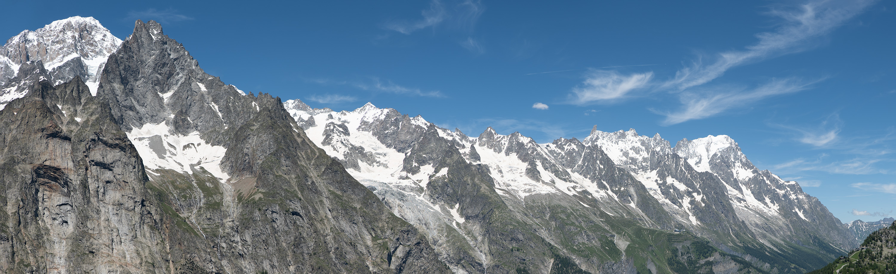
Plate 11 is certainly matched closely by our Plate 12 photograph. Turner has placed the Mont Blanc 4805m or 15,764ft on the extreme left, to give space on his paper to the especially-impressive run of peaks to the North-East. The key point that fixes the location of the view is the relationship between the round white peak of Mont Blanc and the set of sharp peaks that are nearer to us. These are the ‘aiguilles’ or ‘needles’, the main ones being called ‘blanche’ (white), ‘noire’ (black) and ‘rouge’ (red).
In comparing our image with Turner’s sketch, we see some differences, notably in the shape immediately to the right of Mont Blanc: the double-eared Aiguille Blanche de Peuterey 4099m, is wider in Turner’s sketch, but this is simply because our viewpoint is a short distance further East.
The needle providing the best positioning information is the Aiguille Noire de Peuterey 3772m In Turner’s sketch it is about 1/3 from the left, and in our photograph about 1/4 from the left. This needle is much nearer to us, so, as we walk along the TMB, its position relative to Mont Blanc changes markedly. In the sketch and the photograph, the double-top of this needle is very close to the same position against the more distant background, confirming that we are at the same height and very close to the same spot: that lies on today’s usual direct TMB route to Courmayeur.
Turner’s sketching is remarkably accurate. He captures this unique view of the Massif perfectly. In drawing our lines over his, we have followed as best we can, without referring to a photograph. In places these lines are very difficult to detect by eye, so, we may have introduced small errors.
An interesting point of difference due to the more than 220-year time gap, is the glacier just to the right of the Aiguille Noire: the Brenva Glacier. The lower part is nowadays just a smoothed rockface followed by a sloping line of gray rubble hiding whatever ice remains, whereas in Turner’s sketch the valley is full of a deep glacier that spills into the bottom right-hand corner of the sketch. The glaciers on this warmer side of the Massif have receded and thinned enormously, and their decaying nature leaves their surfaces covered in unattractive grey rocks. and bare rockfaces. In Turner’s day this range was full of extending white glaciers that must have made it even more captivating than it is today.
Towards the right is the jagged fairly-level-looking line of the Grandes Jorasses that is 4208m or 13,805ft at its highest point that he had drawn from the opposite side of the Massif when crossing the Mer de Glace. He was a natural topographer. By now he would have constructed in his memory a complete model of the Mont Blanc Massif.
On almost certainly the fourth day, Turner’s by now pretty-well exhausted party would have been delighted to catch their first glimpse of Courmayeur in the Valle d’Aosta. Here, Turner records this view in his Grenoble and Mont Blanc Sketchbook Plate 13. Presumably, the three figures are Newby Lowson, their Swiss guide, and the local guide from Chamonix.
, TB-LXXIV-6 D04498, 215x281mm, Image Lumby20111116-8503.jpeg)
Plate 13 D04498 Official Title by Ruskin and Finberg ‘Descent to Aosta’ detached from The Grenoble Sketchbook LXXIV folio 6, pencil and black ‘chalk’ crayon on paper 215 x 281mm, Image Lumby ref: 20111116-8503
Plate 14 Compare with Plate 12. The view from near today’s TMB refuge de Maison Vieille, with the first view of Courmayeur. The houses are an Eastern extension of the town. Image © Lumby 20130714-2774
Although John Ruskin and later the cataloguer A J Finberg correctly identified this view in general terms, the actual location had remained in doubt. This is because it was generally assumed that Turner’s party had continued what from a map, such as Plate-1, appears to be the most obvious route to Courmayeur along the entire length of the Val Veny, not appreciating the blocking nature of what in Turner’s day would have been the huge lower portion of the already-mentioned Glacier de Miage.
Even today, the recommended TMB route is the one taken by Turner. What is more, the assumption would have been reinforced by Turner making several sketches North of Courmayeur including a detailed, readily recognised, double-page sketch Fig 15 of the exit of the Val Veny into the Valle d’Aosta. From time to time we are easily misled by Turner’s sketches where he decides that he must deviate from his main route in order to record something special that he would otherwise have missed. By including such points sequentially, we can arrive at a false route.
In comparing Plate-13 with Plate-14, we are finally certain of the location and subject of Turner’s sketch.
 on the Right, from near Entreves_Lumby-20111116-8614+8616v2.jpeg)
Plate 15 - Official Title: Mont Blanc, the Brenva Glacier and the Entrance to the Allée Blanche from near Entreves. From the France, Savoy, Piedment Sketchbook TB-LXXIII page 67a, Image Lumby-20111116-8614+8616.
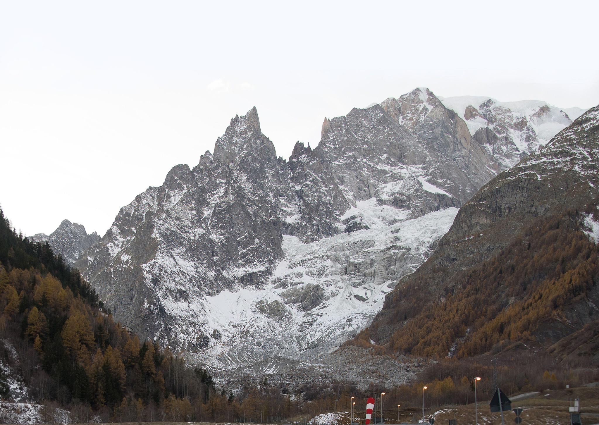
Plate-16 - Compare with Plate-14 - The Aiguille Noire de Peuterey, Mont Blanc de Courmayeur and Brenva Glacier from the main road close to the Skyway roundabout, a little below Turner’s Entrèves Village viewpoint. Image © Lumby 20171117-0347
Turner made several sketches of Mont Blanc as he walked North from near Courmayeur: the opposite direction to that needed to reach Aosta City. Having walked this ourselves, one is compelled to keep moving onwards to see more of the Massif to the left of Mont Blanc, until the view opens up completely where the Val Veny enters the Valle d’Aosta. The sketch Plate-15 appears to include a broken bridge over the Dora di Ferret mountain stream. It seems then that Turner may thereby have been prevented from crossing into the village of Entrèves itself whose houses are in his sketch.
As we view Turner’s sketch along with our Plate-16 photograph, we see the rounded top of the Mt Blanc (de Courmayeur) is on the Right, and for Turner probably in a small amount of cloud. The striking shape in the very centre of Turner’s sketch is the Aiguille Noire de Peuterey. We mentioned earlier that the positioning of this particular aiguille or needle is a helpful indicator of one’s position on the TMB, and here we see just how distant it is from the top of the Mont Blanc (even if somewhat lost in Turner’s sketch by our poor lighting of the fold of his sketchbook).
The viewpoint is close to the Skyway cablecar-lift opened in 2015; said at the time to be the world’s most expensive. It takes visitors to the highest public viewpoint in Italy: Punta Helbronner 3466m / 11371ft. The views are of course remarkable, offering the opportunity to see many of the details of Mr Turner’s sketches from close to. He would have loved it.
Contrary to the generally accepted opinion that JMW Turner made no sketches of his 1802 trek from Chamonix to Courmayeur, probably due to poor weather, we have revealed here for the first time that in fact he made a series of unusually large and mostly very detailed and accurate sketches in excellent weather conditions that have remained unrecognised in his Mont Blanc and Saint Gothard Sketchbook for over 220 years.
We make special thanks to the staff of Tate Britain’s Prints and Drawings Room together with the Curatorial Staff of 2011 that invited us without restriction to undertake this detailed forensic photographic research work with a view to determining and correcting titles of Turner’s works. It is therefore most regrettable that the Tate subsequently banned us for life from continuing this task that we were undertaking entirely at our own expense to independently further Turner scholarship.
Comments, corrections and suggestions are welcom. Please email the authors diect : john.bishop@lumby.ch
Return to the Turner Research index page
This page was updated on March 2nd, 2026
115.png)
Art and Publishing GmbH of Switzerland CHE-209.693.835 All Rights Reserved
The Editor :
please email
Exhibitions - Loans - Purchases :
please email